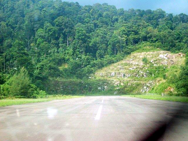
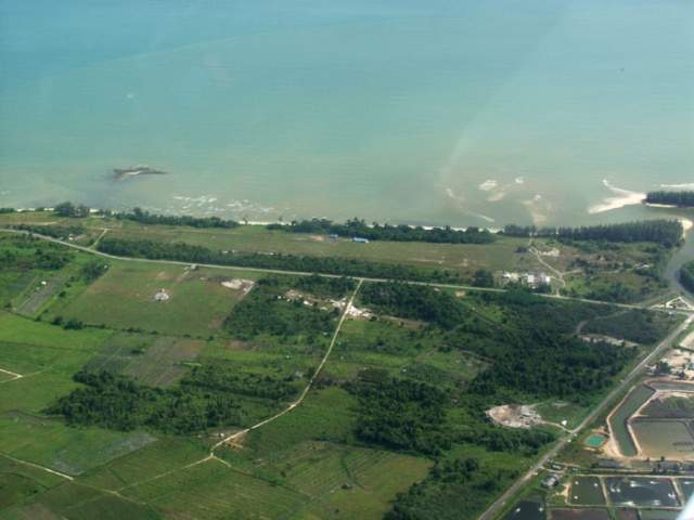
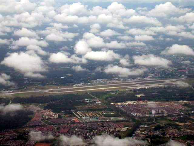
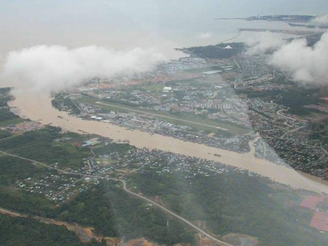
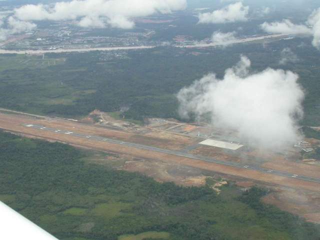
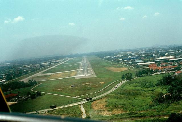
Picture of the Airstrip
[click to enlarge]
Airstrip Information
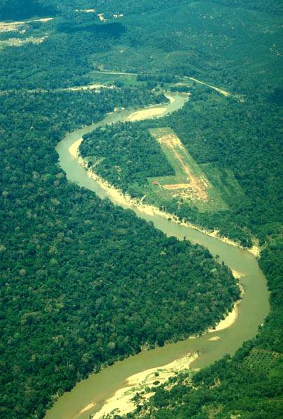
ICAO ID: WMAN
Coordinates: N4*19.8' x E102*23.8'
Rwy Heading: 21/03
Length: 2,700 feet
Altitude: 323' MSL
Surface: Laterite
Slope:
Obstruction:
Frequency:
Contact Info: Captain Noor (Johor Flying Club) James Teng in Singapore
Activities: Also known as Taman Negara (National Park) - which has a high mountain called Gunong Tahan **The highest mountain in Malaysia is Mount Kinabalu at 4100 meters, it is actually the tallest moutain in S.E. Asia.
Land up
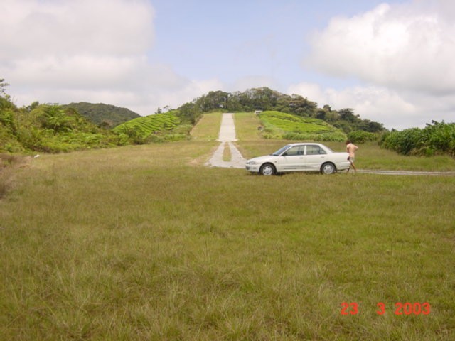
Take off down
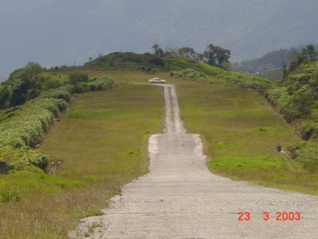
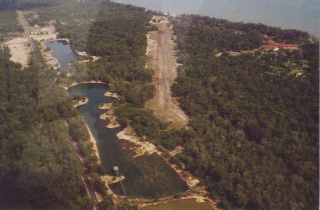
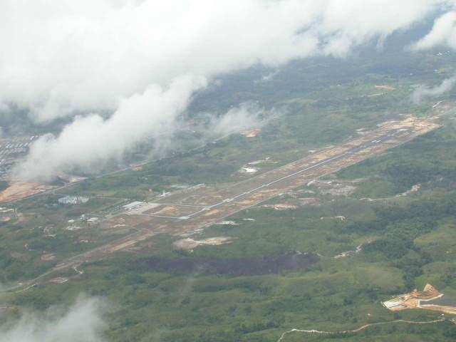
ICAO ID: n/a
Coordinates: N04*26.4' x E101*25.3'
Rwy Heading: 28/10
Length: 1100ft x 70ft
Altitude: 5,400ft (approximate)
Surface: Asphalt
Slope: Vertical rise of 120ft over its length, making a 12% rising gradient (measured by 3d GPS). Land Rwy 28. Takeoff Rwy 10.
Obstruction: On approach to 28, ground rises from the valley floor at least 2000ft in a mile or so. There is plenty of space to maneuver for lining up. The rwy is located on the ridgeline. The first 200ft overrun/undershoot area is long grass and reasonably free from big holes. A few 6ft high bushes at the perimeter. Next, a car track, with asphalted tyre tracks over grass, extends some 600ft further. Total width is 150ft, but the 'improved' part is about 20ft wide. Would be ok even with wheel pants. Both of the above are level, or close to it. After the car track, there is an asphalted runway 1100ft x 70ft, in good condition. At the top of this rise is another flat section, about 200ft wide x 100ft long, also asphalted. At the end of this flat bit is solid vertical rock, 50ft or so high. The procedure would appear to be land touching down on the car track, then adding power to taxi/roll out up the hill to the flat area at the end.
Frequency:
Contact Info: Jon Elliot in Singapore
Activities: Fun place to visit.
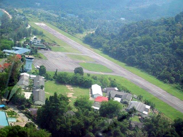
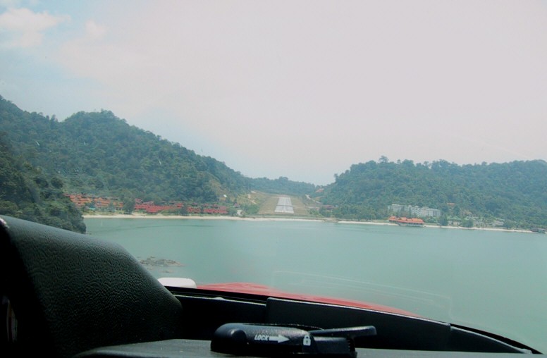
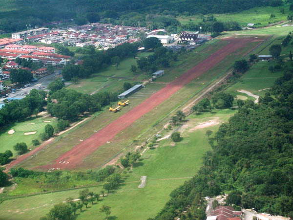
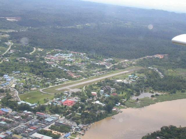
Pulau Tioman
End of Rwy 20
ICAO ID: WMBT
Coordinates: N2*49.1' x E104*09.8'
Rwy Heading: One way: Landing 20, Take off 02
Length: 3000 feet
Altitude: 15 feet
Surface: Asphalt
Slope: Level
Obstruction: See photo
Frequency: 122.8
Contact Info: James Teng in Singapore // Ken in Thailand
Activities: Scuba, Sea sports, Good beach/hotel, Mountain trekking. Tioman is good but a bit touristy.
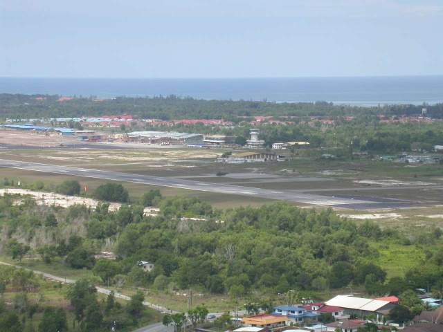
ICAO ID: WMPA
Coordinates: N4*14.7' x E100*33.2'
Rwy Heading: Land 22 / Take off 04
Length: 2600 feet
Altitude: Sea Level
Surface: Tarmac
Slope: very slight uphill
Obstruction: Hill one end, open sea the other
Frequency: Lumut Ctrl 123.5
Contact Info: Ken in Thailand // James Teng in Singapore
Activities: in Perak. Great island, with several resorts from basic to exotic. All the Chinese go there for the special Chinese food. Was a bit wild last time I landed, but I hear they have lengthen the runway and taken out the roll-a-coasters. When I flew out with the 182rg I had to plan on which top I would take off.
ICAO ID:
Coordinates:
Rwy Heading:
Length:
Altitude:
Surface:
Slope:
Obstruction:
Frequency:
Contact Info: Ken in Thailand
Activities: Sittiawan is on the mainland inland from Pangkor, a minimal grass strip about 300 by 300 m, ala English style. Take off in any direction. Except the grass is usually cut in only one direction. Grass height must be checked out before landing. I did a touch and go just see how goes the grass. I just made it out again, because the grass was, and deep too. Had it been full stop, I would have been hiring grass cutters for days to get out again. Between Sittiawan and Pangkor is Lumut, also known for the food, another nice place there and home of the Lumut Yatch Club. I used to sail there frequently. Again nice local culture.
ICAO ID: WMKL
Coordinates:
Rwy Heading:
Length:
Altitude:
Surface:
Slope:
Obstruction:
Frequency:
Contact Info: Ken in Thailand
Activities:
ICAO ID:
Coordinates:
Rwy Heading:
Length:
Altitude:
Surface:
Slope:
Obstruction:
Frequency:
Contact Info: Ken in Thailand
Activities:
ICAO ID:
Coordinates:
Rwy Heading:
Length:
Altitude:
Surface:
Slope:
Obstruction:
Frequency:
Contact Info: Ken in Thailand
Activities: Malacca is a nice airport, also international on notice, and Malacca town very very historic.
ICAO ID: WMAU
Coordinates: on the 210 radial 30 nm from Pulau Tioman.
Rwy Heading: 15/33
Length: 1700 feet including 100 feet of stopway.
Altitude:
Surface: Grass
Slope: n/a
Obstruction: n/a
Frequency: Notice VMR 116.8.
Contact Info: James Teng in Singapore
Activities: There were other 300m strips on the East coast of Malaysia, one at Mersing I used to fly into. Really laid back offshore islands there. Ken in Thailand
ICAO ID:
Coordinates: N06*30.3' x E100*11.4'
Rwy Heading: 18/36
Length: 1800 feet (60 feet wide)
Altitude:
Surface: 500 feet concrete (remaining grass)
Slope:
Obstruction:
Frequency:
Contact Info: Captain Adam Abdullah (club captain)
Activities: Perlis Flying Club
ICAO ID: WMAB
Coordinates: N01* 45.0 x E102*59.0'E
Rwy Heading: 31/13
Length: 4600 ft (width 100ft)
Altitude:
Surface:
Slope:
Obstruction:
Frequency:
Contact Info: Jon Elliot in Singapore
Activities: Useable area; Easternmost 1500ft of field, width 100ft. Scf grass/laterite. Numerous car tracks crossing rwy so exercise caution. Used to be very active microlight area and may still be some around. Keep good lookout when approaching field, and be sure to drag before landing. Beware if you see any military camping in the area as I have been fired upon in the past (with flares!). This is another useful place to go hide if you get stuck short of Johor due weather, although I would favor going back to Malacca. Reported to be under renovation for use as a dedicated freight airfield.
ICAO ID: ZZZZ (DEST/ROMPIN)
Coordinates: N02*51.3' x E103*27.5'
Rwy Heading: 36/18
Length: approx 2100ft rwy sfc + 300ft overrun area at N end. (width approx 50ft, but only the easternmost side serviceable)
Altitude:
Surface: Rwy material concrete but many loose chips and not recommended for acft with wheelpants. Caution; Do not taxi or turn off the runway surface except at the Southern end, where there is a turning bay. Soft sand off the runway will bog down acft even running straight, and is hidden under grass. If acft becomes bogged, call the cook at the restaurant, as he has been trained in unbogging procedures.
Slope:
Obstruction: Recommend landing rwy 18, takeoff rwy 36 due tall trees at South end of rwy. Recommend after landing a responsible person(copilot) disembark from acft prior leaving rwy and marshall into a safe parking position clear of rwy. Beware of parking too close to trees if RON, as branches often fall off during nightly thunderstorms. Recommend a thorough dragging of the rwy prior landing, however keep a good lookout for large raptor birds who seem to hold over the field.
Frequency:
Contact Info: Jon Elliot in Singapore
Activities:
ICAO ID:
Coordinates:
Rwy Heading:
Length:
Altitude:
Surface:
Slope:
Obstruction:
Frequency:
Contact Info:
Activities:
ICAO ID:
Coordinates:
Rwy Heading:
Length:
Altitude:
Surface:
Slope:
Obstruction:
Frequency:
Contact Info:
Activities:
ICAO ID:
Coordinates:
Rwy Heading:
Length:
Altitude:
Surface:
Slope:
Obstruction:
Frequency:
Contact Info:
Activities:
ICAO ID:
Coordinates:
Rwy Heading:
Length:
Altitude:
Surface:
Slope:
Obstruction:
Frequency:
Contact Info:
Activities:
ICAO ID:
Coordinates:
Rwy Heading:
Length:
Altitude:
Surface:
Slope:
Obstruction:
Frequency:
Contact Info:
Activities:
ICAO ID:
Coordinates:
Rwy Heading:
Length:
Altitude:
Surface:
Slope:
Obstruction:
Frequency:
Contact Info:
Activities:
ICAO ID:
Coordinates:
Rwy Heading:
Length:
Altitude:
Surface:
Slope:
Obstruction:
Frequency:
Contact Info:
Activities:
ICAO ID:
Coordinates:
Rwy Heading:
Length:
Altitude:
Surface:
Slope:
Obstruction:
Frequency:
Contact Info:
Activities:
ICAO ID:
Coordinates:
Rwy Heading:
Length:
Altitude:
Surface:
Slope:
Obstruction:
Frequency:
Contact Info:
Activities:
ICAO ID: WMKA
Coordinates:
Rwy Heading:
Length:
Altitude:
Surface:
Slope:
Obstruction:
Frequency:
Contact Info:
Activities:
ICAO ID: ZZZZ (No ICAO indicator)
Coordinates: N01*38.8' x E103*56.0'
Rwy Heading:
Length: 1800 feet (estimate)
Altitude:
Surface: Grass/laterite cropduster strip
Slope:
Obstruction:
Frequency:
Contact Info: Jon Elliot in Singapore
Activities: Good as an alternate if you have been up to Tioman VFR and cant get back to Johor or Seletar due weather and need somewhere closer than Mersing. I saw this one last weekend and it is still OK.
ICAO ID:
Coordinates:
Rwy Heading:
Length:
Altitude:
Surface:
Slope:
Obstruction:
Frequency:
Contact Info:
Activities: